

At a glance
- Era
- The Early Abbasid Caliphate
- Region
- Levant & Iraq
Quick facts
- Domain
- Architecture and building techniques
- Kind
- System
- First attested
- 762 CE · 145 AH
- Era
- Abbasid age
- Where
- Baghdad
- Attribution
- Improvement
Who made it
- Abu Ja'far al-Mansur Commissioner
The claim and its basis
Radial/concentric organization of an Abbasid seat within an older history of circular towns.
Duri names precedents and plan; Le Strange separates ramparts,central area,housing and routes while recording measurement disagreements.
Sources: Bagdat — Abd al-Aziz al-Duri, TDV · Baghdad During the Abbasid Caliphate — Le Strange1900 · Mansur round-city map catalogue — Commons · Futuh al-Buldan — Hitti translation, volumeI,1916 · Tarikh al-Khulafa — al-Suyuti (Dar al-Minhaj edition) · Ahsan al-Taqasim fi Ma'rifat al-Aqalim of al-Muqaddasi · Muruj al-Dhahab — al-Masʼudi
Before it
- Older circular towns including Darabjird and Hatra
How it works
Summary
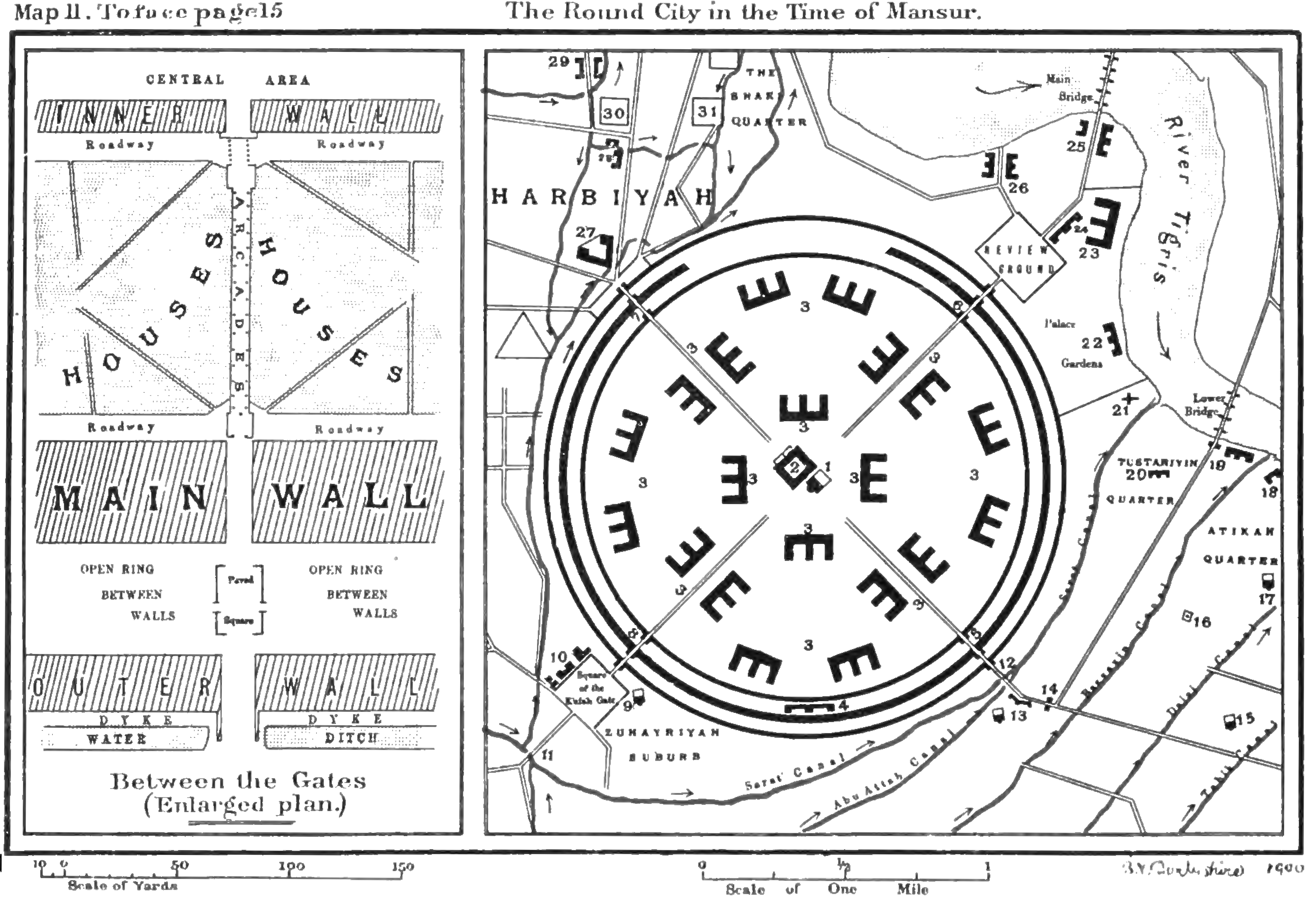
How does a circle become a governmental seat rather than simply an attractive shape? In Baghdad, al-Mansur commissioned a nucleus connecting palace, mosque, entrances, defences and housing. Le Strange distinguishes foundation in 145 AH/762,transfer of treasury and bureaus in 146 AH/763,and completion in 149 AH/766 2. This was neither the first city nor the first circular settlement; Duri names older precedents 1. The image is a reconstruction published 1900,not a surviving 762 engineering document 3. Our subject is a particular arrangement, not every later Baghdad district attributed to a solitary inventor. Regular streets do not prove equally regular or just lives.
What it is
The plan organizes relationships between a centre, entrances and rings. Palace and mosque occupy the central area; four roads approach from the Khurasan, Syrian, Kufa and Basra gates. Between centre and outside lie defences, passages and housing, not identical military functions assigned to every circle 4. Le Strange explains why descriptions can mention two walls while describing three: the outer pair are ramparts, the third encloses the central area and is not counted among the fortifications 5. This distinguishes barrier, road and neighbourhood rather than counting lines without asking what they separate. It also distinguishes Mansur's city from the much larger Baghdad that developed beyond its nucleus.
The world before it
The ground was not a blank page. Duri describes settlements, routes, canals and a setting connected with rivers, resources and communications. He places circular planning among older examples, including Hatra and Darabjird, not at the beginning of human urbanism 1. Even the Abbasid governmental seat did not begin here: Baladhuri in Hitti's translation gives Hashimiyya/Anbar antecedents and an old wall repaired between Tigris and Sarath 6. These attest a landscape with history, not every later wall inherited unchanged. Resemblance to an older town supports comparison; alone it cannot establish that a specific master drawing was transferred, who carried it, or every instrument used.
The story
Duri separates preparation, construction, governmental occupation and completion. His account includes an earlier planning report attributed to Yaqubi; it is not automatically substituted for 762as the start of construction 1. Le Strange pairs 145,146 and 149AHwith762,763 and 766. These pairs come from the source, not a museum conversion or an exact foundation day extracted from apparent precision 2. He also describes work interrupted by rebellion in the Hijaz and al-Mansur's return to oversee building. Moving treasury and bureaus before completion shows that a city could function while construction continued. One date cannot represent the first occupant, last building and every subsequent district.
The maker(s)
Al-Mansur was the political commissioner, not simultaneously every architect, surveyor, brickmaker and water carrier. Duri describes building personnel; Le Strange reports four overseers and Abu Hanifa's involvement in supervision/brick reckoning. We do not assume overseers and architects are identical lists 1 7. Individual evidence supports Muslim identity: Suyuti transmits al-Mansur's self-description of reading/legal learning and a Malik conversation preferring Abu Bakr/Umar 8. The Sunni museum default is an explicit frame, not inference from a caliph's title, private-belief certainty or authentication of every transmission chain. Existing coercion, imprisonment and reported poisoning accounts remain visible; an urban achievement does not erase them 9.
How it works
Imagine entering a gate: after ditch and fortifications come transitions between gateways, then an arcaded road toward the central enclosure. Between circles are routes around the rings and branches into residential streets, not one road through every house 10. A radial route connects outside and centre; a ring route connects neighbouring sectors. This is teaching explanation, not measured traffic simulation. Gates that could be closed show control of access, not merely shorter journeys. Describing a road does not prove everybody enjoyed the same right to use it at every time.
Water followed another network. Le Strange reports water brought to the palace, then lined/covered watercourses connecting the city with outside supplies 11. A circular wall alone cannot explain continued habitation without water and services. Reports of abundance remain transmitted descriptions, not daily operating records or modern drinking-water guarantees. A line on the map supplies neither a verified gradient nor a discharge rate or channel depth absent from the evidence.
The spread
Spread here does not mean every Islamic town copied a circle. Baghdad expanded beyond Mansur's nucleus and onto both Tigris banks 12. A map combining circle, routes and suburbs does not mean everything at its margins was completed at foundation. Some features have later histories; the numbered1900map is not a762 works inventory 3. Duri's account of development likewise shows a changing city, not a picture frozen when the centre was chosen 13. We draw no transmission arrow to a later capital simply because it was planned or had a central palace. A particular historical connection needs evidence of contact, not two similar silhouettes.
What it was built on
The plan drew on older circular towns, local routes/canals and governmental capacity to gather craftspeople and distribute functions 1. Le Strange describes sun-dried and kiln-burnt brick in different settings, reed bundles in construction, and distinctions between rampart mass, facings and vaulted passages 14. The commissioner did not invent those materials. Large reported brick totals are not archaeological counts newly measured today. Competing wall-width/height traditions remind us that reconstruction combines accounts rather than reproducing a surviving contractor's notebook. We can understand material choices by function without claiming the precise mixture of every brick or mortar batch, or treating the drawing as a structural safety specification.
What was built on it
Streets, arcades and the central area changed use after construction. Le Strange reports markets originally along inner roads, then shops removed on al-Mansur's orders and accommodation for traders in Karkh; cleared spaces served guards 15. Duri dates market removal to 773 and discusses security 16. This is functional revision, not a perfect immutable blueprint. Le Strange also describes houses and lanes spreading over plots granted to followers 17. Such changes do not prove every later Baghdad school or library lay inside the circle or resulted directly from its geometry. A nucleus begins an urban history; it is not a single sufficient cause of everything a city later creates.
Impact on daily life
A map makes distance to a palace visible, but life includes trader, water carrier, resident, guard and prisoner. Le Strange names occupational streets, water carriers, the southern Matbak prison and restrictions on riding into the centre 18. Centralized authority therefore cannot simply be translated into equal access. A ruler at the centre, at a distance from the gates, describes spatial order; it does not establish fair distribution of land or taxes. Market relocation could change merchants' journeys and relationships with the centre, but the read sources provide no resident-opinion survey or comprehensive household-cost account. We distinguish effects that can be described from social outcomes that have not been measured.
How it changed history
The nucleus became part of a much larger city and a setting for reading relationships between government, location and construction. Yet Baghdad's centuries cannot be reduced to its first walls. Duri describes expansion, warfare, the caliphal move to Samarra and return, and transformations within the city 13. Not every phase continued the same functional centre. The name City of Peace does not prove absence of conflict; Baghdad's scholarly reputation does not establish that circular form itself produced knowledge. Its specific historical value is a commissioned, relatively dated experiment organizing capital functions in a nucleus, then revealing how a city can exceed its first plan and redistribute work over time.
Who invented it?
The sharper question is who commissioned this nucleus and how it related to precedents. Both sources identify al-Mansur; Duri identifies older traditions. Adaptation/improvement is appropriate, not worldwide priority in circles 1 19. Even compass details disagree: Le Strange places KufaSW/BasraSE,while the read Duri paragraph reverses them. We do not silently correct either and present a precise modern GIS line. Le Strange's nearly 3200 yards external diameter likewise is not automatically identical to Duri's2352m 20 21. Retain disagreement, unit and measured object rather than manufacture a composite certainty neither author states.
Today
The plan can teach distinctions between centre, route, barrier and reconstruction. It is not a complete surviving district whose dimensions can be measured on the image and treated as an archaeological survey. Le Strange's statement about no apparent traces belongs to a book published 1900,not a2026 excavation report 22. Baghdad's existing coordinates identify the general city; we have not moved them to a circle centre inferred from the drawing. A historical-location image, an interpretive diagram and field measurement are different kinds of evidence. We compare this plan with other planned settlements without claiming every later capital descended from it or giving directions to visit/excavate sensitive sites.
Surviving examples
The selected image is Le Strange's MapII,dated 1900,to face 15. Exact Commons metadata identifies its maker and public-domain status 23. It shows circle, entrances, palace/mosque, river/canals and an enlarged wall/passage inset with scales. It illuminates a modern author's reconstruction; it does not become an Abbasid document because it is old today. Chapter15–29was actually read and 17–18 scan images inspected, alongside Hitti445–446 and Suyuti427. This is not a claim to have read every Arabic original in Le Strange's footnotes. The accompanying generic diagram is a modern conceptual comparison chain, not a replacement city map or a resolution of measurement disputes.
In culture
A circle offers a strong image of authority at a centre, but a strong image can conceal differences between functions and people. Le Strange's upper gate chambers and entrance restrictions are transmitted accounts of place/rank, not scenes whose complete colours and conversations we know 24. He also reports stories connecting iron gates with Solomon; a transmitted gate-origin story is not established manufacturing history or an artifact this museum examined 25. We neither turn religious narrative into archaeological certification nor render a verdict on belief. Likewise, Abu Hanifa's reported supervisory involvement does not cancel accounts of conflict with al-Mansur. Work and coercion remain different contexts in the existing biography.
For young readers
Draw a paper circle, four equally spaced entrances and a centre. Four90-degree quarters total 360. Join each entrance to the centre, then draw a ring connecting the sectors. Travel with a pencil between neighbouring entrances, once through the centre and once around the ring: different route types, not measured historical journeys. Add cards for house, water and market, and explore what changes when an entrance closes. Use no flame, combustible material or digging; historical layout stories do not need physical reenactment. This is a modern paper exercise, not a762Baghdad map or proof that the most attractive shape gives everyone equal opportunities.
References
- 26 Duri's first article, not all separately signed Baghdad sections.
- 27 Actual chapter/map reading;17–18/PDF51–52 images inspected.
- 23 Exact image,1900 date and public-domain metadata.
- 6 PDF461–462 images; margin287is not Hitti's printed page.
- 28 Earlier account retained;427 image inspected for individual identity evidence.
- 29 30 References retained in the original city record/prose, not a claim those original pages were reread in this batch.
Connections
People and things also explored
Sources
- Bagdat — Abd al-Aziz al-Duri, TDV , Foundation and plan
- Baghdad During the Abbasid Caliphate — Le Strange1900 , p.15–16
- Mansur round-city map catalogue — Commons
- Baghdad During the Abbasid Caliphate — Le Strange1900 , p.17–19
- Baghdad During the Abbasid Caliphate — Le Strange1900 , p.18
- Futuh al-Buldan — Hitti translation, volumeI,1916 , p.445–446
- Baghdad During the Abbasid Caliphate — Le Strange1900 , p.17
- Tarikh al-Khulafa — al-Suyuti (Dar al-Minhaj edition) , p.427
- Tarikh al-Khulafa — al-Suyuti (Dar al-Minhaj edition) , p.426
- Baghdad During the Abbasid Caliphate — Le Strange1900 , p.21–27
- Baghdad During the Abbasid Caliphate — Le Strange1900 , p.28–29
- Baghdad During the Abbasid Caliphate — Le Strange1900 , p.15
- Bagdat — Abd al-Aziz al-Duri, TDV , Development
- Baghdad During the Abbasid Caliphate — Le Strange1900 , p.17–23
- Baghdad During the Abbasid Caliphate — Le Strange1900 , p.25–26
- Bagdat — Abd al-Aziz al-Duri, TDV , Markets
- Baghdad During the Abbasid Caliphate — Le Strange1900 , p.26–27
- Baghdad During the Abbasid Caliphate — Le Strange1900 , p.26–29
- Baghdad During the Abbasid Caliphate — Le Strange1900 , p.15–19
- Baghdad During the Abbasid Caliphate — Le Strange1900 , p.17–18
- Bagdat — Abd al-Aziz al-Duri, TDV , Measurements
- Baghdad During the Abbasid Caliphate — Le Strange1900 , p.16–17
- Mansur round-city map catalogue — Commons , MapII
- Baghdad During the Abbasid Caliphate — Le Strange1900 , p.23–24,28–29
- Baghdad During the Abbasid Caliphate — Le Strange1900 , p.20–21
- Bagdat — Abd al-Aziz al-Duri, TDV , Foundation and plan,Markets,Measurements,Development
- Baghdad During the Abbasid Caliphate — Le Strange1900 , p.15–29,MapII
- Tarikh al-Khulafa — al-Suyuti (Dar al-Minhaj edition) , p.426–427
- Ahsan al-Taqasim fi Ma'rifat al-Aqalim of al-Muqaddasi , p.107–109
- Muruj al-Dhahab — al-Masʼudi , p.276–278
Cite this page
islam.museum contributors. “Baghdad's round-city nucleus plan”. islam.museum, https://islam.museum/en/invention/round-city-baghdad/. CC BY-SA 4.0. Last updated 2026-11-13.
Improve this page on GitHub · Report an error · Help complete it · JSON